Level, Spot or RL Survey: A Complete Guide for Accurate Land Measurement
- masum
- April 25, 2026
- Uncategorized
Introduction
Have you ever wondered whether a piece of land is truly level or has hidden high and low points? This is an important question in construction, land surveying, and site development. Even a small height difference can cause drainage problems. weak foundations, and uneven roads.
That is why is essential. It helps measure exact ground elevation. land slope, and surface condition for accurate planning. In simple words. this survey helps engineers and builders make safer, stronger, and more cost-effective projects.
Why is Level, Spot or RL Survey Important?
Many people think land is flat just by looking at it. But land often has hidden slopes and uneven surfaces. Even small level differences can create major problems in construction.
For example, if a house is built on uneven land without proper leveling. rainwater may collect around the foundation. Over time, this can weaken the structure. A road built without correct leveling may develop waterlogging and cracks.
That is why ground level measurement, site elevation survey. And RL calculation are essential before construction starts. These surveys reduce mistakes and improve planning.
They also help engineers estimate how much soil needs to be cut or filled. This saves money and avoids waste during land preparation.
Types of Level, Spot or RL Survey
1) Level Survey
A Level Survey measures vertical distance between points. It helps determine whether land is higher or lower compared to another point.
This method is widely used in road construction. bridge work, rail projects, and foundation planning. It helps create smooth and balanced structures.
Surveyors use leveling tools like auto level machines. Dumpy levels, and digital levels for accurate readings.
2) Spot Level Survey
A Spot Level Survey focuses on measuring specific points. Each measured point gives a clear elevation value.
When many spot levels are collected, surveyors can create a land profile. This shows the shape and slope of the area.
This method is common in land development. plot planning, drainage design, and contour mapping.
3) RL Survey
Reduced Level Survey is more detailed and technical. It calculates elevation from a known benchmark.
This benchmark may be linked to sea level or another approved fixed point. All measurements are taken from this reference.
This method provides highly reliable survey benchmark data. Accurate elevation records, and construction level planning.
Main Tools Used in Level Survey
Several tools are used to perform properly.
The first tool is a Level Machine. This is used to observe and record height differences.
The second is a Tripod Stand, which keeps the machine stable.
Another important tool is the Leveling Staff. This is a marked measuring rod used for reading elevation points.
Modern surveys may also use GPS surveying tools. Total Station equipment, and digital leveling instruments for better accuracy.
Tips for Accurate Survey Work
Always check equipment calibration before starting work. Even a small machine error can create wrong results.
Choose a strong benchmark point. This helps keep measurements accurate throughout the survey.
Survey Process Step by Step
Understanding the survey process is very important. When you know each step, the full idea becomes clear. A good survey follows a planned system. This creates better and more accurate results.
1) Site Inspection
The first step is visiting the land. Surveyors walk across the area and check the ground condition. They look at slope, soil type, trees, water flow, and nearby structures. This helps them understand what kind of land measurement survey is needed.
They also identify possible problems. Some land may be soft, muddy, or hard to access. Some places may have obstacles like walls, ponds, or heavy vegetation. Early inspection saves time later.
2) Selecting a Benchmark
A benchmark is a fixed point with known elevation. This point becomes the base reference for the full survey. Every other height is measured from this point.
Choosing a strong benchmark is very important. It should be stable and easy to find later. A wrong benchmark creates wrong RL measurement results.
3) Setting Up the Instrument
The level machine is placed on a tripod stand. It must be set on stable ground. Then it is adjusted until the instrument becomes perfectly level.
If the instrument is not balanced, readings become inaccurate. This affects the full site level survey. Proper setup is one of the most important parts of surveying.
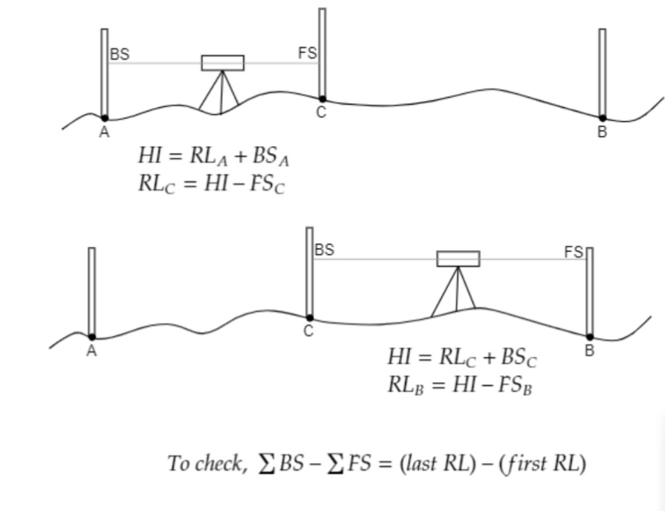
4) Taking Staff Readings
Next, a leveling staff is placed on measured points. The surveyor reads the value through the level machine. These readings show height difference between points.
This process continues point by point. I many readings are taken across the site. This creates complete ground elevation data.
5) Calculating Reduced Level
After fieldwork, readings are calculated. Surveyors use standard formulas to find exact RL values. These numbers show actual land elevation.
This calculation helps engineers design roads, buildings, drains, and foundations correctly. Accurate reduced level calculation creates accurate planning.
Where Level, Spot or RL Survey is Used
Construction Projects
Every building starts with land checking. Engineers need to know if the ground is level or sloped. This helps design a safe foundation.
Without proper construction level survey, buildings may face settlement problems. Cracks and water damage can happen later. Good leveling reduces these risks.
Road Construction
Roads must follow planned slopes. If leveling is wrong, rainwater stays on the road. This weakens the road surface.
A proper road level survey ensures smooth driving . better drainage, and longer road life. This is why leveling is always done before road work begins.
Drainage Planning
Water always moves from high land to low land. A survey helps engineers understand natural flow direction.
This helps design drains, canals, and stormwater systems properly. Good drainage survey planning reduces flooding and waterlogging.
Land Development
Before making housing projects or industrial zones, developers need land data. They need to know high points, low points, and slope patterns.
A detailed spot elevation survey helps plan roads. plots, parks, and drainage systems efficiently.
Agriculture
Farmers also benefit from land leveling. Uneven land causes water waste. Some areas get too much water while others stay dry.
Proper farm land leveling survey improves irrigation and crop production.
Benefits
One big benefit is accuracy. It gives clear data instead of guesswork. Better data creates better planning.
Another benefit is cost saving. Wrong land planning causes expensive mistakes later. Accurate survey work reduces rework.
It also improves safety. Strong foundations and proper drainage protect buildings and roads.
A good survey also saves time. Engineers can make quick decisions when they have clear elevation mapping data.
Common Survey Mistakes to Avoid
One common mistake is using uncalibrated equipment. This creates false readings.
Another mistake is poor note-taking. If field notes are unclear, calculations become difficult.
Bad weather can also affect survey work. Strong wind, rain, or heat waves may reduce reading quality.
Final Thoughts on
A basic but very important part of land surveying. site planning, and construction work. It helps measure land height correctly and shows the real shape of the ground. This makes planning easier and safer.
A proper survey improves ground level accuracy. supports better drainage design, and helps create strong foundations. It also saves time, lowers cost, and reduces mistakes during construction.
Quick Tips
- Always choose a strong benchmark.
- Check survey tools before work.
- Take multiple readings for accuracy.
- Keep field notes clear and organized.
- Use modern digital surveying tools when possible.
Bottom Line / Review
If you want safe construction and smart land planning, is essential. It gives clear elevation data, supports good design, and helps avoid costly errors. In simple words, better survey means better project success.
Related Posts