Contour Survey (2D and 3D)
- masum
- April 28, 2026
- Uncategorized
Introduction
Have you ever looked at a piece of land and wondered, “Is this land flat, sloping, or full of hidden ups and downs?” This is a very important question in construction, land development, and engineering. A small height difference in land can create big problems later. Water may collect in the wrong place, roads may become weak, and buildings may face foundation issues.
This is where Contour Survey (2D and 3D) becomes very useful.
A Contour Survey is a land surveying method used to measure the height and shape of the ground. It shows the high points, low points, slopes, and surface details of a land area. Surveyors use this information to create maps and 3D models that help engineers, architects, and developers make smart decisions.
In simple words, a contour survey helps us “see the shape of land” before construction starts.
Today, modern technology has made contour surveying more advanced. We now have 2D contour mapping and 3D contour modeling, both giving powerful land information for better planning.
In this article, you will learn everything about Contour Survey, how it works, its types, benefits, uses, and practical tips.
What is Contour Survey?
A Contour Survey is the process of measuring land elevation and showing equal height points with contour lines on a map.
These lines connect points that are at the same height above sea level.
For example:
- One line may show land at 5 meters height
- Another line may show 10 meters height
- Another may show 15 meters height
- Hills
- Valleys
- Slopes
- Flat land
- Drainage paths
- High and low spots
This information is very useful in land mapping, site planning, civil engineering, and construction design.
Why Contour Survey is Important
Contour surveying is important because land is rarely perfectly flat.
Even a small slope can affect:
- Building foundation
- Water drainage
- Road design
- Pipeline layout
- Landscaping
- Flood protection
Without proper contour data, a project can face expensive mistakes.
For example:
If rainwater flows toward a building instead of away from it, flooding can happen.
A contour survey helps avoid this problem before construction starts.Contour Survey (2D and 3D)
That saves:
- Money
- Time
- Labor
- Repair cost
Understanding Contour Lines
Contour lines are the heart of contour surveying.
These are curved lines on a map that connect equal height points.
Simple rule:
Same height = same contour line
1) Close Lines = Steep Slope
When contour lines are close together, land rises or falls quickly.
That means steep land.
This is common in hills or mountain areas.
Construction becomes harder in these places.
2) Wide Lines = Gentle Slope
If contour lines are far apart, land changes height slowly.
That means gentle slope.
This land is easier for:
- Housing projects
- Roads
- Farming
- Parks
3) Circular Lines = Hill or Depression
Closed contour circles can show:
- A hill
- A pit
- A basin
Surveyors read contour patterns carefully.
What is 2D Contour Survey?
A 2D Contour Survey creates a flat map view of land with contour lines.
It shows:
- Height points
- Boundaries
- Roads
- Buildings
- Trees
- Drain lines
- Surface features
It looks like a technical land map.
Engineers use it for planning.
Architects use it for design.
Developers use it for land analysis.
Benefits of 2D Contour Survey
Easy to Understand
2D maps are simple.
Professionals can quickly read land shape.
This speeds up decision making.
Cost Effective
2D surveying is usually cheaper than 3D modeling.
Small projects often choose 2D mapping.
Fast Delivery
Survey data can be processed quickly.
This saves project time.
Good for Basic Planning
Perfect for:
- House construction
- Small roads
- Drainage planning
- Plot development
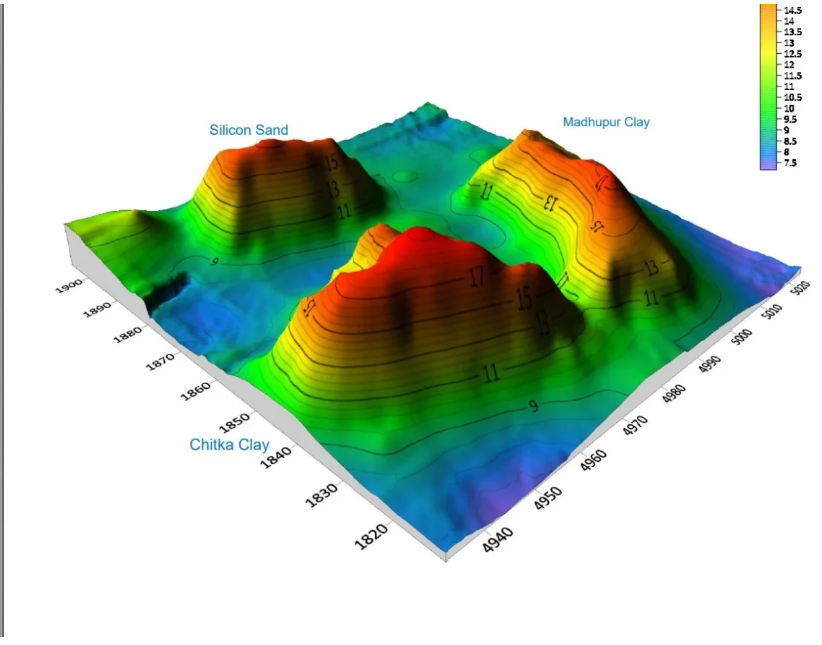
What is 3D Contour Survey?
A 3D Contour Survey creates a three-dimensional model of land.
Instead of flat lines, you can see:
- Real land height
- Surface depth
- Hills
- Slopes
- Valleys
- Structures
It feels like viewing land in real shape.
This gives deeper understanding.
3D surveys are made using modern technology like:
- Drone survey
- GPS survey
- LiDAR scanning
- Total Station survey
- Digital terrain modeling
Benefits of 3D Contour Survey
Better Visualization
Clients can easily understand land shape.
Even non-technical people can see site conditions clearly.
This improves communication.
High Accuracy
3D models capture many elevation points.
This increases precision.
Accurate data means better planning.
Advanced Analysis
Engineers can study:
- Water flow
- Earthwork volume
- Cut and fill calculation
- Slope safety
- Risk areas
Smart Construction Planning
3D contour data supports better construction decisions.
Projects become more efficient.
2D vs 3D Contour Survey
| Feature | 2D Survey | 3D Survey |
| View | Flat map | Real model |
| Cost | Lower | Higher |
| Accuracy | Good | Very high |
| Visualization | Basic | Excellent |
| Analysis | Limited | Advanced |
| Best For | Small projects | Large projects |
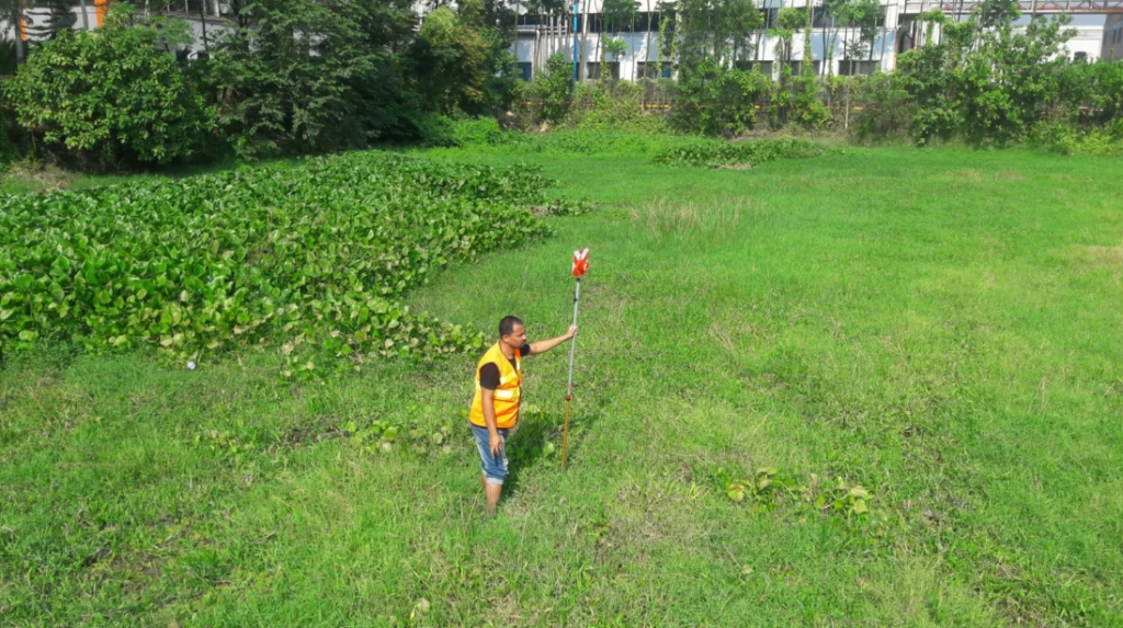
Methods Used in Contour Survey
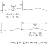
There are different methods used in Contour Survey (2D and 3D). The method depends on land size, project type, and required accuracy. Some methods are traditional, while others use modern digital technology. Each method has its own benefits.
1) Direct Method of Contour Survey
The Direct Method is one of the most accurate contour survey methods.
In this method, surveyors go directly to the land and find points that have the same elevation. Then they connect those points to create contour lines. This method takes time, but it gives very reliable results.
It is mostly used for small areas where very high accuracy is needed.
For example:
- Building sites
- Small bridge projects
- Land leveling work
- Precise engineering design
2) Indirect Method of Contour Survey
The Indirect Method is faster than direct surveying.
Here, surveyors first collect many spot levels from different points on land. Contour Survey (2D and 3D) Then they create contour lines later by calculation and drawing.
This method saves time.
It is widely used because it is practical for medium and large projects.
Common techniques include:
- Grid method
- Cross-section method
- Radial line method
- Tacheometric survey
3) Grid Method Survey
The Grid Method is very popular.Contour Survey (2D and 3D)
In this method, land is divided into square grids. Heights are measured at each grid corner. After that, contour lines are drawn between equal elevations.
This creates a detailed land map.
It is excellent for:
- Housing projects
- Commercial land planning
- Site grading
- Industrial development
4) Cross Section Method
The Cross Section Method is mostly used in long projects.
Surveyors measure levels across lines at fixed distances. These sections show the land profile.
This method is perfect for:
- Roads
- Highways
- Railway tracks
- Pipelines
- Drainage canals
It helps engineers understand slope changes along long routes.
Equipment Used in Contour Survey
Modern contour surveying uses advanced tools for better speed and accuracy.
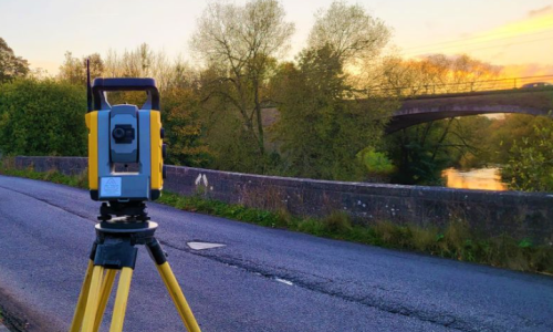
Total Station
A Total Station is one of the most important survey tools.
It measures:
- Distance
- Angle
- Height difference
- Coordinates
It is fast and highly accurate.
Most professional contour surveys use Total Station technology.
It also stores digital data for mapping software.
GPS Survey Equipment
Modern GPS surveying gives accurate location data.Contour Survey (2D and 3D)
It helps surveyors collect:
- Horizontal position
- Vertical elevation
- Ground coordinates
GPS works well for large land areas.
It is faster than many traditional methods.
RTK GPS gives very high precision.
Drone Survey
Drone surveying is changing land mapping.
A drone flies over land and captures:
- High-resolution images
- Surface elevation data
- Terrain details
- Digital models
It is very fast.
It can cover large land in less time.
Drone surveys are excellent for:
- Large development projects
- Mining land
- Agriculture mapping
- Flood area mapping
- Construction planning
LiDAR Technology
LiDAR Survey is one of the most advanced methods.
LiDAR sends laser pulses to the ground. It measures how long the light takes to return. Contour Survey (2D and 3D) This creates very detailed 3D land data.
It can capture:
- Surface elevation
- Vegetation height
- Ground shape under trees
- Hidden terrain details
LiDAR gives extremely accurate 3D models.
It is widely used in major engineering projects.
Contour Survey
A contour survey follows a planned process.
1: Site Visit
Surveyors first inspect the land.
They study:
- Land condition
- Access roads
- Obstacles
- Vegetation
- Existing structures
- Survey scope
2: Establish Control Points
Control points are fixed reference points.
These points help maintain survey accuracy.
Every measurement connects to these reference points.
Without control points, data quality becomes weak.
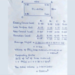
3: Collect Elevation Data
Surveyors then collect height information.
They measure many points across land.
More points mean better contour detail.
Data collection may use:
- Level instrument
- Total Station
- GPS
- Drone
- LiDAR
4: Data Processing
Collected field data is processed in software.
Software converts raw points into:
- Contour lines
- 2D maps
- 3D surface models
- Terrain analysis reports
5: Final Survey Report
The final output may include:
- Contour map
- Elevation table
- 3D land model
- Site analysis
- Volume calculation
- Slope map
Practical Tips for Better Contour Survey
Survey During Clear Weather
Rain can create measurement errors.Contour Survey (2D and 3D)
Dry weather gives better data quality.
Take More Points
More elevation points mean better contour detail.
Less guessing.
More accuracy.
Use Modern Technology
Drone and GPS surveys save time.
They also improve precision.
Check Data Twice
Always verify field data. Contour Survey (2D and 3D)
Small mistakes can create big design problems later.
Match Survey with Project Need
Small project = 2D survey may be enough.
Large project = 3D survey gives better results.
Contour Survey (2D and 3D)
A Contour Survey is used in many industries because land shape matters in almost every development project. Whether it is a small home construction project or a large industrial development, contour data helps experts make better plans.
1) Building Construction
Before building starts, engineers need to understand the land condition.
They need to know:
- High points
- Low points
- Natural slope
- Water flow direction
- Soil surface condition
A contour survey provides this information clearly.
2) Road and Highway Projects
Roads cannot be built randomly.
Engineers must study elevation changes carefully.
Contour maps help them understand:
- Slopes
- Curves
- Drainage path
- Earth cutting areas
- Filling areas
This improves road safety and design quality.
3) Land Development Projects
Real estate developers use contour surveys before project planning. Contour Survey (2D and 3D)
It helps them decide:
- Plot layout
- Road network
- Utility lines
- Open spaces
- Landscape design
Good land planning increases project value.
4) Agriculture and Farming
Farmers also benefit from contour surveying.
It helps in:
- Irrigation planning
- Water control
- Soil conservation
- Land leveling
- Terrace farming design
Better contour planning improves crop production.
5) Mining and Quarry Work
Mining projects need detailed land data.
Contour surveys help calculate. Contour Survey (2D and 3D)
- Excavation volume
- Surface change
- Pit depth
- Material stockpile volume
- Safe slope design
3D contour mapping is especially useful here.
Advantages of Contour Survey
There are many benefits of using contour surveys
Better Planning
Good information creates good planning. Contour Survey (2D and 3D)
Contour data helps professionals make smart decisions early.
Cost Saving
Wrong land planning can be expensive.
Contour surveying helps avoid:
- Unnecessary excavation
- Drainage failure
- Design changes
- Repair cost
Higher Accuracy
Modern surveying tools provide precise data.
This improves engineering quality.
Time Efficiency
Advanced surveying methods are fast.
Drone mapping and GPS surveying reduce field time greatly.
Limitations of Contour Survey
Like every method, contour surveying also has some challenges.
Cost Can Be High
Advanced 3D surveys can be expensive.
Drone and LiDAR systems cost more.
Small projects may not need that level of detail.
Weather Problems
Heavy rain, fog, and strong wind can affect survey quality.
Drone surveys especially depend on weather.
Large Data Handling
3D surveys create huge amounts of data.
Processing takes powerful software and skilled analysis.
Future of Contour Survey
The future of contour surveying is very exciting.
Technology is making surveys smarter, faster, and more accurate.
Future trends include:
- AI-based land analysis
- Drone automation
- Cloud mapping systems
- Real-time GPS surveying
- Digital Twin modeling
- Smart GIS integration
- Advanced 3D terrain simulation
Bottom Line / Review
Contour Survey (2D and 3D) is one of the most important land surveying services in modern engineering and construction. It helps us understand land elevation, slope, and natural surface shape before work begins. Contour Survey (2D and 3D)
A 2D contour survey is simple, practical, and cost-effective for normal planning. A 3D contour survey gives deeper analysis, better visualization, and high precision for complex projects.
Both methods are valuable.
The right choice depends on your project needs.
If you want:
- Better planning
- Better drainage
- Lower construction risk
- Cost savings
- Accurate land development
Then a professional Contour Survey is a smart investment.Contour Survey (2D and 3D)
Related Posts